The Atlanta Donut Ride
- Distance: 10.2 mi
- Elevation gain: 778 ft
- Maximum elevation: 1,155 ft
- Elevation loss: 669 ft
- Minimum elevation: 896 ft
- Moving time: 1 h 15 m
- Moving speed: 8.1 mph
- Maximum speed: 18.8 mph
- Total time: 2 h 49 m
- Global speed: 3.6 mph
- Date: 05/20/2023
Interactive map
GPS track profile
About this GPS track
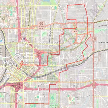
Name: The Atlanta Donut Ride GPS track, route, trail
Coordinates: 33.73661 -84.39126 33.78243 -84.35048
Topography: Atlanta topographic map
Other GPS tracks
Click on a GPS track to view route, its statistics and profile.
Atlanta Critical Mass bike ride
United States > Georgia > Fulton County > Atlanta
Distance: 8.8 mi • Elevation gain: 679 ft • Maximum elevation: 1,184 ft
Atlanta Critical Mass
United States > Georgia > Fulton County > Atlanta
Distance: 14.5 mi • Elevation gain: 1,096 ft • Maximum elevation: 1,122 ft