Valley Loop Hike
- Distance: 1.8 mi
- Elevation gain: 190 ft
- Maximum elevation: 1,079 ft
- Elevation loss: 190 ft
- Minimum elevation: 928 ft
Interactive map
GPS track profile
About this GPS track
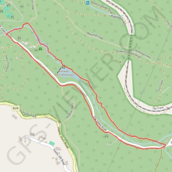
Name: Valley Loop Hike GPS track, route, trail
Coordinates: -35.01784 138.64552 -35.01020 138.65729
Topography: Adelaide topographic map
Other GPS tracks
Click on a GPS track to view route, its statistics and profile.
Belair National Park - Mount Lofty
Australia > South Australia > Adelaide
#Bike
Distance: 8.1 mi • Elevation gain: 1,650 ft • Maximum elevation: 2,310 ft