More biking around Seattle
- Distance: 13.2 mi
- Elevation gain: 827 ft
- Maximum elevation: 174 ft
- Elevation loss: 719 ft
- Minimum elevation: -3 ft
Interactive map
GPS track profile
About this GPS track
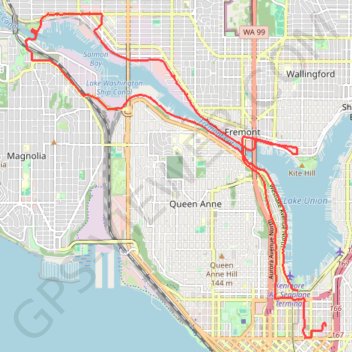
Name: More biking around Seattle GPS track, route, trail
Coordinates: 47.61844 -122.39960 47.66871 -122.33091
Topography: Seattle topographic map
Other GPS tracks
Click on a GPS track to view route, its statistics and profile.
Biking around Seattle
United States > Washington > King County > Seattle
Distance: 29.6 mi • Elevation gain: 1,335 ft • Maximum elevation: 180 ft