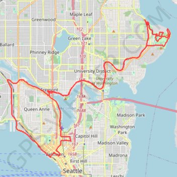
Biking around Seattle
- Distance: 29.6 mi
- Elevation gain: 1,335 ft
- Maximum elevation: 180 ft
- Elevation loss: 1,329 ft
- Minimum elevation: -3 ft
- Moving time: 3 h 17 m
- Moving speed: 9.0 mph
- Maximum speed: 40.3 mph
- Total time: 5 h 31 m
- Global speed: 5.4 mph
- Date: 07/15/2023
Interactive map
GPS track profile
About this GPS track
Name: Biking around Seattle GPS track, route, trail
Coordinates: 47.61133 -122.38626 47.69072 -122.24635
Topography: Seattle topographic map
Other GPS tracks
Click on a GPS track to view route, its statistics and profile.
More biking around Seattle
United States > Washington > King County > Seattle
Distance: 13.2 mi • Elevation gain: 827 ft • Maximum elevation: 174 ft