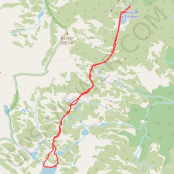
Bezbog Hut - Popovo Lake - Bezbog Hut
- Distance: 4.7 mi
- Elevation gain: 1,348 ft
- Maximum elevation: 7,759 ft
- Elevation loss: 1,335 ft
- Minimum elevation: 7,188 ft
- Moving time: 3 h 12 m
- Moving speed: 1.5 mph
- Maximum speed: 2.6 mph
- Total time: 4 h 2 m
- Global speed: 1.2 mph
- Date: 08/21/2018
Interactive map
GPS track profile
About this GPS track
Name: Bezbog Hut - Popovo Lake - Bezbog Hut GPS track, route, trail
Start: Bezbog hut, Bansko, Blagoevgrad, Bulgaria (41.73477 23.52550)
End: Bezbog hut, Bansko, Blagoevgrad, Bulgaria (41.73469 23.52539)
Coordinates: 41.70937 23.50718 41.73477 23.52550
Topography: Blagoevgrad topographic map
Other GPS tracks
Click on a GPS track to view route, its statistics and profile.
Bezbog Hut - Mt. Polezhan - Mt. Bezbog - Bezbog Hut
Distance: 5.0 mi • Elevation gain: 2,260 ft • Maximum elevation: 9,288 ft