Bezbog Hut - Mt. Polezhan - Mt. Bezbog - Bezbog Hut
- Distance: 5.0 mi
- Elevation gain: 2,260 ft
- Maximum elevation: 9,288 ft
- Elevation loss: 2,260 ft
- Minimum elevation: 7,343 ft
- Moving time: 3 h 53 m
- Moving speed: 1.3 mph
- Maximum speed: 2.6 mph
- Total time: 5 h 41 m
- Global speed: 0.9 mph
- Date: 08/03/2015
Interactive map
GPS track profile
About this GPS track
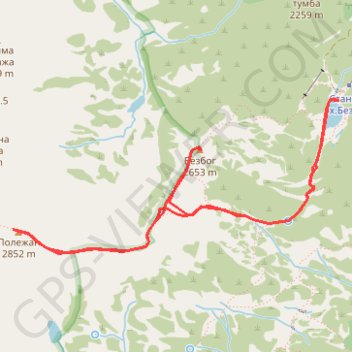
Name: Bezbog Hut - Mt. Polezhan - Mt. Bezbog - Bezbog Hut GPS track, route, trail
Start: Bansko, Blagoevgrad, Bulgaria (41.73397 23.52412)
End: Бай Славе, Bansko, Blagoevgrad, Bulgaria (41.73380 23.52451)
Coordinates: 41.72371 23.49570 41.73397 23.52451
Topography: Blagoevgrad topographic map
Other GPS tracks
Click on a GPS track to view route, its statistics and profile.
Bezbog Hut - Popovo Lake - Bezbog Hut
Distance: 4.7 mi • Elevation gain: 1,348 ft • Maximum elevation: 7,759 ft